Wednesday Newsfeed: Severe weather risks increase as low pressure develops (+3 Maps)
1/10/2024 3:00pm

> From the WeatherWatch archives
High pressure continues to move off NZ to our east and this means windy nor’westers in some regions on Wednesday. As this happens a low pressure zone will form along the western coastline of the country, and this will help feed in rain or showers to many regions.
Let’s get into the forecast for Wednesday to begin with…
RAIN:
Heavy rain sets into the southern half of the West Coast and will spread into other western and north-western areas of the South Island too. Colder rain moves into Southland and Otago. In the North Island showers are most likely in northern facing regions like BoP and Northland.
WIND:
Nor-west winds will strengthen further over eastern parts of NZ from about Christchurch to Wellington to Gisborne. Mild northerlies for northern NZ and colder south to south-easterlies in the lower South Island.
TEMPERATURES:
Colder air moves into Southland and Otago, but those further north are generally warmer than average today.
DAYS AHEAD
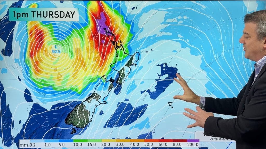
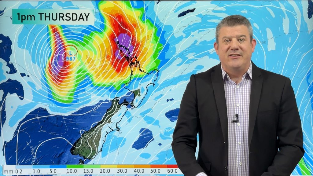
On Thursday a large area of low pressure deepens around NZ. A sub-tropical airflow dragged down behind the departing high pressure zone will help feed rain, possibly heavy, into the eastern South Island and also around East Cape in the North Island. Elsewhere around NZ showers and patchy rain are possible.
By Friday high pressure surrounds that low in the Tasman Sea and that helps break up the rain bands. Large dry areas return to the North Island and likely across the upper South Island (although with low pressure nearby being specific about that a couple days out is a bit tricky. Rain or showers are still likely to continue in the lower half of the South Island, being fed in from the east. Your local forecast will be better at drilling down deeper on potential rainfall, temperatures, wind and cloud cover).
This weekend the low moves in to NZ from the Tasman Sea bringing rain and showers – and then it falls apart, leaving a showery north-westerly flow in it’s wake.
- Our ClimateWatch outlook for October and our eye on La Nina will be issued this afternoon.


Keep up to date with MetService warnings and watches – there are a number of them – and as always, drill down deeper with your hyper-local, hourly, 10 day forecasts at WeatherWatch.co.nz – or download the Free WeatherWatch App.
Comments
Before you add a new comment, take note this story was published on 1 Oct 2024.
Latest Video

Subtropical storm moving in, gales and some heavy rain, especially Thu/Fri
Heavy rain and gale winds will slowly move down the country over the next 24 to 36 hours a subtropical…
Related Articles
Subtropical storm moving in, gales and some heavy rain, especially Thu/Fri
Heavy rain and gale winds will slowly move down the country over the next 24 to 36 hours a subtropical…
Tropical storm to bring severe weather to NZ, gales & heavy rain
A tropical cyclone is today leaving the tropics and will grow into a larger storm system for a time in…
Tropical low to bring wind & rain this week
A low exiting the tropics near New Caledonia this week will grow larger in the Tasman Sea and finally bring…


Add new comment