Wednesday Newsfeed: Large pool of low pressure brings northern rain today + possible weekend offshore storm (+9 Maps)
16/07/2024 10:20pm

> From the WeatherWatch archives
Weak low pressure will linger over the upper North Island today bringing early fog patches, daytime low cloud and some rain and showers.
Elsewhere not a lot is happening with more fog around NZ and any frosty weather quickly becoming confined to alpine areas as milder air moves in over the days and nights ahead.
Low pressure means clouds can form quickly – some times fog can form then clear, only to give way to cloud or rain soon after.
Driest weather will be in southern NZ (Southland, Otago) and the West Coast.
Most places have light or lighter winds over Wednesday and Thursday.


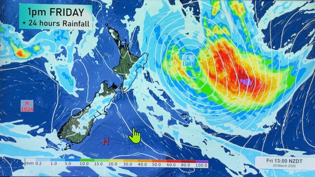
OFFSHORE NORTH-EASTERN STORM THIS WEEKEND?
As we’ve been discussing in our weather videos this week there is the chance of a short lived storm forming to the north east of the North Island on Friday night/or Saturday/Sunday. It’s been a bit ‘off and on’ in the various modelling these past few days – but it does have the chance to bring heavy rain and bigger seas/waves once again to the eastern North Island. No two lows are ever identical in all features – but sometimes you can have the right conditions to produce some repetitive weather and that’s what the eastern North Island might have to contend with again.
Some weather events have perfect conditions to form, others have complicated conditions – and that’s why sometimes weather forecasters can know what is happening with accuracy 10 days out, and other times we need to wait until much closer to the event. This one may take a few more days to lock in with more precision, so we’ll have more details on the latest computer models out today, in our weather video around the middle of the day.


- WeatherWatch.co.nz
- Mobile App
Comments
Before you add a new comment, take note this story was published on 16 Jul 2024.
Latest Video

A tropical low next week *might* affect NZ
It’s not locked in yet, but a tropical storm may end up drifting southwards towards NZ about one week from…
Related Articles
A tropical low next week *might* affect NZ
It’s not locked in yet, but a tropical storm may end up drifting southwards towards NZ about one week from…

Australia: Will Tropical Cyclone Narelle track along half of Oz’s entire coastline?
Tropical Cyclone NARELLE has formed and is heading into northern parts of FNQ, the Katherine region of NT and then…
NZ 9 Day: Two subtropical lows, but a lot of dry weather
In our extended outlook today we track two subtropical storms, one that will likely miss most of NZ while the…


Add new comment