Wednesday Newsfeed: Big low may affect NZ for over a week (Updated Maps & FAQs)
11/06/2024 8:50pm

> From the WeatherWatch archives
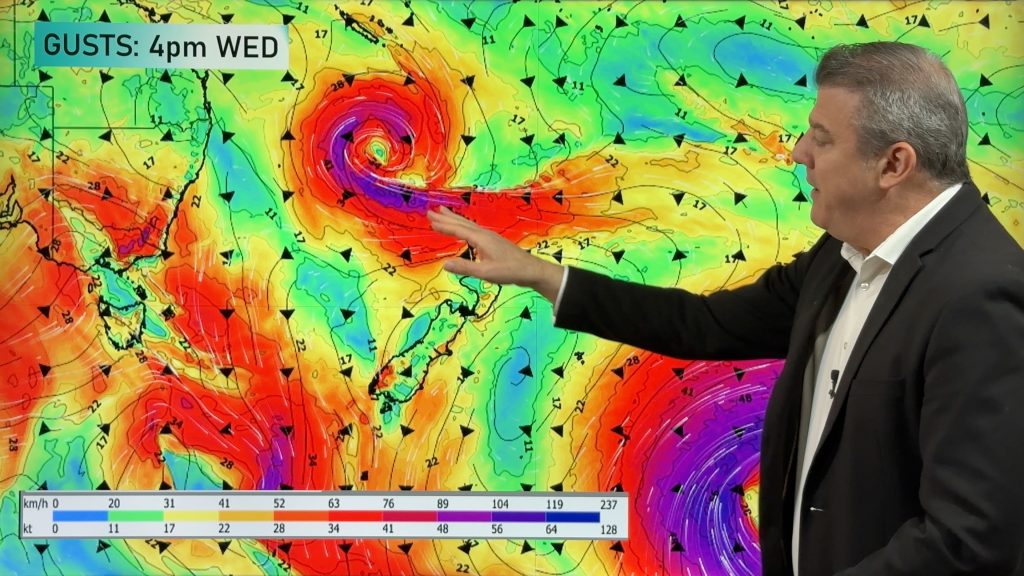
For the first time this year a large area of low pressure will affect the entire country, possibly for over a week. The low develops across Wednesday and Thursday over the Tasman Sea courtesy of another system further south. The new low then spins in milder air from north of NZ which will deepen the system.
It will bring more cloud, rain and showers into NZ – and yes, some severe weather too. Like we said yesterday, this low zone brings instability – but there’s a good chance many places won’t have severe weather either. Our next weather video on Wednesday should be able to lock in more detail.
Long range modelling is now suggesting this system may hang around the country for over a week. But the low may also “wobble” and instead of stalling entirely in one area it may spin like a washing machine with an uneven load, and cause it to move further away from the country…or closer to us. Long range modelling has been struggling with this very issue for days.
So uncertainty remains about precise severe weather risks – but confidence is building that low pressure is likely to hang around well into next week across NZ and/or the Tasman Sea.
Colder air will make for a cold start on Wednesday with frosts expected in the morning across the South Island.
But milder winds come in on Wednesday PM in the lower South Island and then the North Island on Thursday PM – along with cloud and then rain later.
The centre of the low will be stretched out – that means the centre isn’t stormy, but the lower air pressure means the atmosphere is unstable. Put short, the forecast later this week and weekend is a changeable one and don’t be surprised to see rainfall totals moving around – along with whether or not some days will be dry or pouring with rain.
There are fine lines between dry and wet for a number of regions as this low deepens, stalls, and then finally moves on next week.
Because the low is potentially going to be stuck over the Tasman Sea near NZ for several days, and because it may not have a stormy centre, it means some regions will have fairly benign weather at times too. Watch our daily weather videos to make more sense of it all.
FAQs
Is this a big storm?
We tend to class a “storm” as something with gale force winds around most of the centre and while this system is large it doesn’t look to fit that category – so won’t likely be problematic for everyone. But it does bring a variety of severe weather risks from Heavy Rain and Severe Gales, to Heavy Snow and Thunderstorms. Because the low is large it means those risks extend across more regions – but the larger size doesn’t always increase the intensity of severe weather and large calm and dry areas will also be in the mix (especially thanks to our mountains and ranges interrupting the flow of weather). For now, WeatherWatch.co.nz is mostly describing this as a “large low bringing some severe weather risks to both main islands”.
Is this a major snow event?
For the Southern Alps cold air mixing with sub-tropical moisture can produce very heavy snow. It’s too early to lock in how much will fall in the mountains because the shape and precise location of the low’s centre later this week hasn’t yet been determined. At this stage, this does not look like a major snow event for most places – but we must point out the cold air capable of doing this will be very near southern NZ (in other words, this is still something to monitor closely this week). For now, the bulk of the coldest air looks to be heading towards Tasmania and the central Tasman Sea – to the west of NZ. This may still change – this is not locked in yet but is the current best thinking.
Is this a subantarctic or a subtropical system?
It’s a bit of both. You may note this coming Saturday’s current weather map shows how the coldest air gets sucked up from the Southern Ocean region over the Tasman Sea and into the western side of NZ – but at the same time a milder subtropical feed comes into Dunedin and the lower South Island much further south. This isn’t a very “typical” setup for NZ but highlights how large the low is and NZ’s unique location on earth being stuck between both subtropical and subantarctic airflows. In the coming days they mix together like someone mixing hot and cold water in a bath.
Will snow fall to sea level?
No, this is not likely based on any of today’s modelling.
Will snow fall in the main cities of the South Island?
No, not at this stage – it’s looking too mild by a few degrees.
It looks like a tropical cyclone or hurricane – is it the same?
While they can look similar – and are both low pressure zones – cold centred lows outside of the tropics (as opposed to warm centred tropical cyclones) means the wind energy is spread out over a greater distance and the rainbands are far more broken up and fractured. A tropical cyclone has all the wind energy at the centre but these colder lows can have much calmer centres and their windier weather can spread hundreds of kilometres from the centre, in a much more messy way. The centre of these lows are lazier and unstable and rain bands and thunderstorms can form suddenly even out of clear skies.
Why can’t forecasters be more specific about the risks yet?
Firstly, the low still hasn’t even formed yet. Secondly, large lows like this can have gales on one side, calm on the other. Rain on one side, dry on the other. They can produce widespread areas of weather to monitor – from heavy rain, snow, gales and thunderstorms, but NZ’s mountains and ranges complicate the forecast further – so that’s why it takes time to lock in. A slight shift in a forecast airflow, from a south-easterly to a southerly may not seem like much on a nationwide weather map – but our mountains and ranges can mean that small shift is the difference between your area having snow or not, rain or not, gales or not etc. The forecast will become much clearer over the next couple of days.
Will everyone have severe weather?
No, based on modelling over the past few days severe weather looks to be in many of the usual parts of NZ – ie, mountains, ranges and exposed areas and some other more populated areas may also be exposed – that’s the part we can’t lock in this far out due to the nature of this low. The closer the centre gets to NZ the more instability there is and the higher risk of pockets of severe weather. In fact, from a rain perspective, Canterbury, Wairarapa and Hawke’s Bay may not get much from this system based on today’s data.
Which areas are most at risk?
It’s remains too early to be precise about this – as the low is forming in an unpredictable way, which is seeing daily modelling updates shift around. The South Island’s West Coast and also coastal Otago may see some heavy rain, along with Taranaki to Bay of Plenty. The best way to monitor the severe weather possibilities is by using our forecasts which update all your hyper-local data every single hour. That on top of MetService watches and warnings (which may not appear for a couple more days) and our daily weather videos should help you make sense of all the information already out there. There will be large dry areas in the mix too. Remember this low hasn’t yet even formed – so being highly detailed about severe weather risks is still a bit tricky.
Will travel plans be affected?
Yes, highways and flights may be impacted by weather conditions later this week and weekend due to this low pressure system. Snow on the alpine highways and passes is possible – so too is black ice and potential pockets of slips and flooding. Low cloud, fog, heavy rain and strong winds may play a role with any flight delays or cancellations, especially with smaller prop planes. We don’t anticipate many issues with international flights but again low pressure zones can create some areas of instability which can change weather conditions at some airports. But please note, most airlines and pilots make the decision to fly or not around the time of departure. Questions about flights are not something we can answer outside of general weather risks. Hopefully any possible cancellations will be at a minimum, but some pockets of disruption are possible.


- WeatherWatch.co.nz
- New Alerting App – Get fewer nasty surprises. Set your own criteria for multiple alerts over multiple locations, including push notifications for MetService warnings across multiple regions. $6.99 for alerts. Or, try the FREE version – it’s still NZ’s largest weather data app!
Comments
Before you add a new comment, take note this story was published on 11 Jun 2024.
Latest Video

NZ 8 Day: High pressure to return, also monitoring tropics next week
A cooler change is moving into NZ tonight and Saturday then winds ease further on Sunday as high pressure starts…
Related Articles
NZ 8 Day: High pressure to return, also monitoring tropics next week
A cooler change is moving into NZ tonight and Saturday then winds ease further on Sunday as high pressure starts…

Unsettled Thu/Fri, high pressure returns this weekend & next week
Wind and some wet weather is moving into both ends of NZ today and tomorrow bringing broken up rain bands…
Subtropical low, windy for some, then high pressure slowly returns
It’s cloudy and windy for parts of New Zealand today with the North Island especially gloomy under cloud associated with…


Add new comment