VIDEO: Storm to come close to North Island on Saturday
17/07/2024 11:59pm

> From the WeatherWatch archives
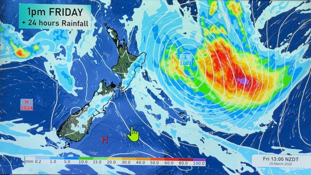
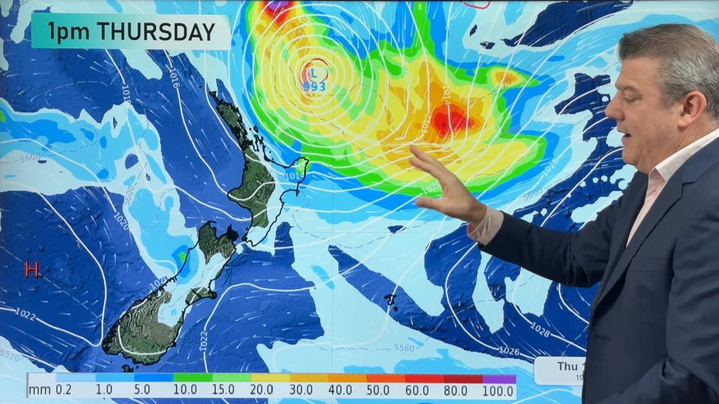
An offshore storm will rapidly develop on Friday PM and by Saturday will be a storm. The low may technically reach the “weather bomb” status (bombogenesis) when the air pressure drops more than 24hPa in 24 hours.
But the good news is the storm – for now anyway – looks to mostly miss NZ, but may still drop some heavy rain in the north, and some windy weather on Saturday for a time.
We have the latest maps. We also take a look at how next week is kicking off.
Comments
Before you add a new comment, take note this story was published on 17 Jul 2024.
Latest Video

Australia: Will Tropical Cyclone Narelle track along half of Oz’s entire coastline?
Tropical Cyclone NARELLE has formed and is heading into northern parts of FNQ, the Katherine region of NT and then…
Related Articles
Australia: Will Tropical Cyclone Narelle track along half of Oz’s entire coastline?
Tropical Cyclone NARELLE has formed and is heading into northern parts of FNQ, the Katherine region of NT and then…
NZ 9 Day: Two subtropical lows, but a lot of dry weather
In our extended outlook today we track two subtropical storms, one that will likely miss most of NZ while the…
Subtropical low (yes, another one) to brush the NI, high pressure still in charge
A subtropical low will power up over the next 24 hours and brush past the north-eastern corner of the North…


Add new comment
janet on 18/07/2024 4:15am
hi may i please ask why you are not showing the rain amounts anymore thankyou
Reply
WW Forecast Team on 18/07/2024 4:46am
Hi Janet, we have daily rainfall maps here for free at WW. We tend to use the rainfall maps you refer to in our videos on Fridays. But we understand why you may have noticed the reduction in rainfall maps in our videos lately – simply we don’t yet own the rights to that data and we have been given some “examples”. We’re still evaluating accuracy before using them more frequently.
Government owned: NIWA and MetService give free maps to NZ media, but not always us. NZ Government puts profits ahead of public service.
Cheers for the feedback
WW
Reply
Ryan on 18/07/2024 12:08am
Hi great videos
Been watching and wondering what (if any) impact these lows will have in the South Island (particularly wanaka and queenstown) for snow showers?
We are travelling from Perth for ten days on Sunday
Reply