VIDEO (Australia): Cyclone Alfred (Thursday) – Gales, rain, huge seas – the latest info
6/03/2025 1:22am

> From the WeatherWatch archives
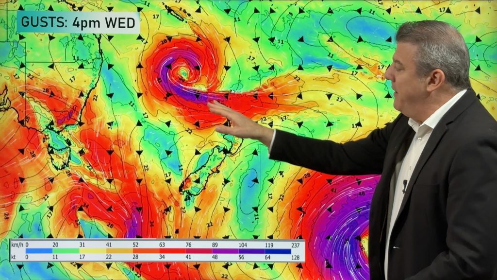
Cyclone Alfred remains a Category 2 tropical cyclone and is still expected move into Brisbane and surrounding regions tonight and through Friday. The cyclone has a bit of a messy path as it’s basically in an area that allows it to stall off and on – meaning it may move westwards, then stop, even move in a circle for a time.
We break down wind, rain and waves – plus how Alfred’s remnants may affect Sydney and other large parts of NSW going into the start of next week.
This is a messy cyclone to be precise about – we do our best to break it all down.
We have another Cyclone Alfred special update on Friday morning Queensland time.
Comments
Before you add a new comment, take note this story was published on 6 Mar 2025.
Latest Video

NZ 8 Day: High pressure to return, also monitoring tropics next week
A cooler change is moving into NZ tonight and Saturday then winds ease further on Sunday as high pressure starts…
Related Articles
NZ 8 Day: High pressure to return, also monitoring tropics next week
A cooler change is moving into NZ tonight and Saturday then winds ease further on Sunday as high pressure starts…

Unsettled Thu/Fri, high pressure returns this weekend & next week
Wind and some wet weather is moving into both ends of NZ today and tomorrow bringing broken up rain bands…
Subtropical low, windy for some, then high pressure slowly returns
It’s cloudy and windy for parts of New Zealand today with the North Island especially gloomy under cloud associated with…


Add new comment
Allan Kennedy on 6/03/2025 6:36pm
Brilliant observations. it’s a shame we can’t get this standard of weather reporting in Australia from the BOM
Reply
Vivienne on 6/03/2025 8:54am
Thank you for your wonderful explanations, we have children in Brisbane so it’s helpful to understand the possibilities.
Reply
Ian on 6/03/2025 3:24am
What is the likelihood waves will form onto the NZ West Coast?
Reply
WW Forecast Team on 6/03/2025 4:38am
Hi Ian, best chance looks to be end of next week if Alfred creates a new low pressure zone exiting the southern NSW coastline: https://www.weatherwatch.co.nz/maps-radars/marine/swell
– WW
Edit Fri AM: Looking less likely anything will reach NZ now.
Reply