Updated Rainfall and Snowfall accumulation maps for New Zealand (+4 Maps)
1/09/2018 11:48pm

> From the WeatherWatch archives
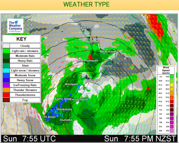
What a difference a day makes. Much of the country has noticed a windier, cloudier or wetter Sunday as a low moves into NZ. As that deep low churns over the South Island on Monday most will feel the colder southerly spread up the country for the start of the new working week.
This low will move northeast across the South Island on Monday and then will change shape and direction of travel, moving over the east of the North Island slowly on Tuesday. The low may then stay near the eastern North Island till Thursday, and the rain, showers and cooler weather is expected to continue in the east all/most of next week there.
On Tuesday, at the same time as this low sits east of the North Island, a narrow ridge of high pressure will develop over the south of the South Island. The ridge is expected get close to the low moving slowly away. So strong and cool southerly quarter winds will blow across central and northern New Zealand. The incoming high will also lock in cooler air bringing some frosts this week inland.
From Monday to Tuesday the north of the South Island will have some snowfall. Snow accumulations may reach warning level in the upper South Island mountains and ranges over the next 12 to 24 hours, while the threat continues into Tuesday for the mountains of Marlborough.


– WeatherWatch.co.nz
Comments
Before you add a new comment, take note this story was published on 1 Sep 2018.
Latest Video

High pressure grows, but a stormy end to next week possible
A settled weekend is on the way and apart from a few isolated showers in both main islands many regions…
Related Articles
High pressure grows, but a stormy end to next week possible
A settled weekend is on the way and apart from a few isolated showers in both main islands many regions…

A tropical low next week *might* affect NZ
It’s not locked in yet, but a tropical storm may end up drifting southwards towards NZ about one week from…
NZ 9 Day: Two subtropical lows, but a lot of dry weather
In our extended outlook today we track two subtropical storms, one that will likely miss most of NZ while the…


Add new comment