Tropical trouble: NZ may just get swiped by a low this week, cyclones further north possible (+4 Maps)
15/01/2023 4:26am

> From the WeatherWatch archives
A series of tropical lows are continuing to form north of New Zealand as we go through January – with more rain likely in a couple regions this week as the first low swipes the north eastern corner of the North Island.
Rain and some wind will likely impact East Cape, Gisborne, Northern Hawke’s Bay and perhaps Bay of Plenty mid to late this week – and behind it more lows are likely to form around the Coral Sea and Vanuatu. WeatherWatch.co.nz says it’s a messy set up but another tropical cyclone, or two, are possible in the coming week or so north of New Zealand, offshore for now.
Highest risk areas for a cyclone to form would be the central/eastern Coral Sea and around New Caledonia and southern half of Vanuatu.
New Zealand is more protected than it was earlier this month, thanks to an uptick in high pressure in our part of the world. The highs – like the one tracking over NZ this weekend – are centred further south which leaves northern NZ more vulnerable to easterlies and lows from the tropics (or sub-tropics) as they track by. It also explains why many in the South Island are asking if a drought is forming with such dry weather continuing on (also some wet weather is coming later this week for a few South Island regions).
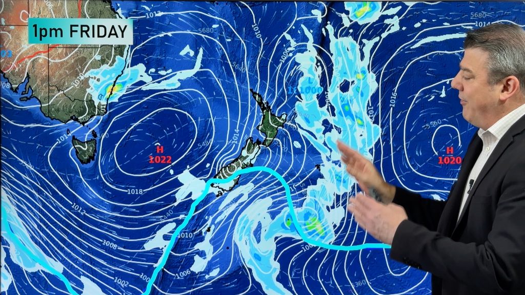
Mid this week Low 1 will be near East Cape while Low 2 will be up near New Caledonia/Vanuatu. Low 2 may form into a Tropical Cyclone. The Fiji Metservice agrees with a “moderate” risk of tropical cyclone formation this coming week for Low 2.
By this Saturday Low 1 will have gone from New Zealand, but Low 2 (possibly an ex-tropical cyclone at this point) will now be near East Cape. It may well remain out at sea and not impact holiday plans – but is one to watch as it may also churn up some eastern beaches.
Also a new low – which we call Low 3 – forms again in the Coral Sea. This means the Saturday weather map for next weekend look remarkably similar to the weather map for this coming Wednesday (see below).
But there is plenty of high pressure also coming out from south of Australia in the southern NZ area for now, also tracking from west to east – which is why these tropical lows aren’t all making it down the country. The incoming high pressure means more dry, settled, summer weather is on the way. Most regions lean drier than average for the next week ahead (East Cape the exception).
A weak cold front at the end of this coming week will bring some rain and showers into the West Coast and patchy falls across Southland. This will see temperatures fall next weekend. Dunedin’s highs will only be around 15 to 17 degrees next Saturday and Sunday while inland places like Gore will go from highs near 30 degrees on Thursday to late teen highs by Friday/Saturday.
However, it’s worth noting this cooler change late week in the south is ahead of yet another block of high pressure moving in.
So, high pressure is so far keeping many of these tropical lows offshore (other than ex-TC Hale last week).
IN A NUTSHELL:
The low coming in this week (Low 1) brings some likely rain to East Cape and surrounding regions. Low 2 may miss NZ as an ex-tropical Cyclone (but one to watch as too early to lock in). Low 3, forming in the Coral Sea later this coming week, is worth monitoring too as it also tracks South-East towards New Caledonia, Vanuatu and maybe to the north of New Zealand in over a week.
Still confused?
Your hyper-local WeatherWatch.co.nz & RuralWeather.co.nz forecasts use IBM Watson, the world’s most accurate weather super computer. These forecasts factor in all the various models, and lows & highs, to give you the most likely weather forecast at ALL locations across NZ, 24/7/365.

LOW 1 is expected to bring in some rain and wind to East Cape, Gisborne and surrounding regions.
LOW 2 deepens in the tropics and may well become a Tropical Cyclone.

The map looks the same, but LOW 1 has now cleared past New Zealand, and the low pressure system near East Cape is LOW 2 (which now may be an ex-tropical cyclone by then. One to watch. The low pressure zone in the Coral Sea is LOW 3, yet another low pressure zone forming.


WeatherWatch.co.nz
Comments
Before you add a new comment, take note this story was published on 15 Jan 2023.


Add new comment
Andy on 15/01/2023 7:59am
“101hPa” at east cape on Thursday? (last map) That’s some serious low pressure!!
Reply
WW Forecast Team on 15/01/2023 1:13pm
lol, a glitch in the matrix Andy. There will be a central pressure there in that low of around 1000hpa.
Cheers
WW
Reply