> From the WeatherWatch archives
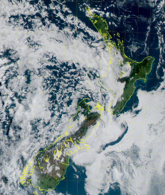
As WeatherWatch.co.nz forecast last week the incoming high for this weekend may not be so sunny for everyone due to something called “anti-cyclonic gloom”.
This is a layer of fairly low cloud that is trapped under the centre of the high – and today that centre is drifting in over the North Island.
As the high tracks east it drags this lower level layer of cloud with it. The ranges and mountains in New Zealand then block this cloud, holding it up like a dam blocking water in the west. This creates cloudy weather in the west and sunny weather in the east. This is the set up today in the North Island where the centre of the high is located.
Over the South Island there are some cloudy areas, mainly coastal with sunniest/clearest skies inland.
 – 12:45pm image by Japanese Meteorological Agency
– WeatherWatch.co.nz
Comments
Before you add a new comment, take note this story was published on 7 May 2017.


Add new comment
remco remmelink on 7/05/2017 1:52am
Why do we have another cyclone with the letter D
Reply
WW Forecast Team on 7/05/2017 2:06am
There are two different naming bodies in our part of the world and both start each season at A….so the Aussie’s named Debbie but Fijian’s named Donna. The line between the two official government cyclone forecasters runs north to south about half way across the Tasman Sea so depending on whether a low forms east or west of this line decides whether it’s Australia or Fiji that names the storm. Australia named Debbie, Fiji named Donna. We’ve seen storms in the past cross back and forth along this line meaning official tracking switches agencies. It’s a silly confusing set up for our part of the world when you think all of North America has just one! 🙂 ^Phil.
Reply