NZ VIDEO: Heavy rain, frosts, gales & a solar eclipse – how the next week is shaping up
19/09/2025 12:03am
High pressure is bringing a burst of wind and rain for many over Friday and Saturday – but gales return to the South Island overnight Saturday and across Sunday – with windy nor’westers reaching “damaging” criteria around the Southern Alps. These strong winds move further into the North Island on Sunday but also ease by night time.
Rain may also become an issue in the north-west corner of the South Island (like Tasman region) and up to about Mt Taranaki. Keep up to date with MetService warnings and watches.
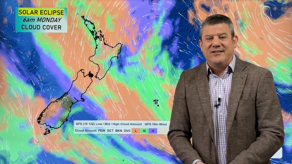
Monday, for the partial solar eclipse, looks a bit unsettled – with cloudy weather covering large parts of NZ. Don’t forget the free WeatherWatch NZ App, and our RuralWeather.co.nz website has cloud forecasts for every NZ location under “Trends” to help guide you.
Next week some wet weather continues as another low moves in from the Tasman Sea bringing more windy westerlies at times. But for some, it may not be as cold next week as the past week or two have been.
Finally, we look to the Northern Hemisphere where 3 tropical lows are worth monitoring in India, Hong Kong, China and Japan. One may become a super typhoon and track near (or into) Hong Kong.
*Programming Note: It’s possible our Monday video may be delayed a couple hours. It’s not for sure, but in case it’s late here’s your heads up! Have a great weekend 🙂
Comments
Latest Video
Yes, NZ’s weather is warming back up again
Temperatures lift on Wednesday for many, then further going into Thursday and Friday as subtropical and/or nor’westers return. Cooler southerlies…
Related Articles
Yes, NZ’s weather is warming back up again
Temperatures lift on Wednesday for many, then further going into Thursday and Friday as subtropical and/or nor’westers return. Cooler southerlies…
ClimateWatch: MARCH is looking quite orderly to start with
Storms near Antarctica, Autumn’s westerlies building south of Australia & NZ, high pressure again affecting both nations and the tropics…
Colder tonight for many, Lunar eclipse Tuesday, high pressure dominates
A lot of low pressure is spinning east of the country while a large high is moving in – this…


Add new comment
Another on 21/09/2025 2:24am
Another 40 days off no sun again is it
Reply