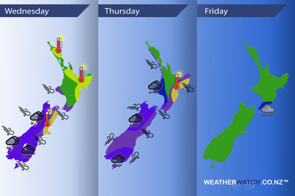
InfoGraphic: The main Weather News Highlights across NZ for next 3 days
17/01/2017 6:00pm

> From the WeatherWatch archives
An anticyclone is centred west of the North Island in the Tasman Sea today with a west to southwesterly airflow pushing in. The South Island sees a strengthening west to northwesterly airflow, a front moves onto the lower South Island later in the evening. A front pushes off the northern South Island on Thursday morning then over the North Island during the afternoon, meanwhile strong southwesterlies lie over the rest of the country. Southwesterlies ease on Friday with a ridge pushing in later in the day.
Wednesday – Weather is looking very unsettled later in the day / overnight. A check of metservices official warnings for the South Island and the lower North Island would be advised due to the incoming weather.
Blue – Areas of rain heavy at times during the day for the West Coast, torrential falls possible in the evening with thunderstorms. Rain may be heavy about Southland and Otago in the evening also with a chance of thunderstorms inland then easing overnight. Very heavy rain spreading into the Canterbury high country evening / overnight with thunderstorms possible also.
Purple – Northwesterlies strengthen for the upper South Island and about the lower North Island from afternoon, winds will likely rise to gale perhaps even severe gale for exposed areas. Strong to gale NW winds develop for the West Coast of the South Island by evening. Strong to gale NW winds spread into Otago by dawn on Thursday, gale SW winds move into Southland by dawn on Thursday morning.
Yellow – Temperatures lifting into the mid to late 20 mark.
Thursday – A check of metservices official warnings for New Zealand would be advised if you may be affected by wind on Thursday. Rain is heavy also for some parts however the wind will be the main factor especially about southeastern parts of the South Island.
Blue – Heavy rain eases early in the morning about North Westland and Nelson / western Marlborough, becoming heavy during the morning about the western North Island for a time then easing in the afternoon as a southwest change moves through.
Purple – Strong northwesterlies for some parts of the North Island, gales through Cook Strait then easing a tad from afternoon as winds tend a little more westerly. The upper South Island in the east sees brisk to strong northwesterlies ease during the afternoon as a southwest change moves in. Southland and Otago see gale southwesterlies (possibly severe gale) from morning then easing late afternoon / evening.
Yellow – Temperatures in the mid 20’s for the east of the North Island in the afternoon.
Friday
Blue – Conditions calm down plenty on Friday however early morning showers about the lower North Island may be heavy before easing.

– Please note, the idea behind this update is to focus on the main weather highlights, which is why not all regions are mentioned.
For specific 10 day information for your city, town, rural community or island please see the 1500 forecasts on our homepage!
– Aaron Wilkinson, WeatherWatch.co.nz
Comments
Before you add a new comment, take note this story was published on 17 Jan 2017.


Add new comment