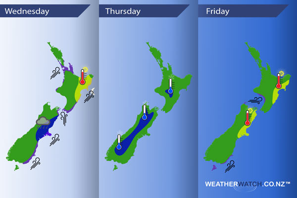
InfoGraphic: The main Weather News Highlights across NZ for next 3 days
3/01/2017 6:00pm

> From the WeatherWatch archives
A southwesterly airflow lies over New Zealand today, within this flow a cold change moves northwards pushing up the eastern side of the country during the day. Southwest winds easing on Thursday as a high pushes in from the Tasman Sea. Westerlies on Friday ahead of a front which moves onto the lower South Island late morning reaching the lower North Island overnight, this front will weaken a fair amount during the day as it moves northwards.
Wednesday
Blue – Shower activity may become heavy for a time this afternoon about Canterbury then easing in the evening. A low risk of hail / thunder.
Purple – Strong southwesterly winds spread up the coastal fringes of the eastern South Island during the morning, reaching Wellington mid afternoon then pushing up the North Island’s east coast in the evening.
Yellow – High’s reaching the mid 20’s for the eastern North Island and parts of the Bay Of Plenty in the afternoon.
Thursday
Blue – There is the chance of a light frost to start the day about inland parts of both Islands. Likely not going below 0, perhaps hovering around 1 or 2 around dawn. Something for growers to take note of.
Friday
Purple – Westerlies become brisk about the lower North Island in the west from afternoon. Brisk to strong southwesterlies about the southeastern coastline from late afternoon.
Yellow – Afternoon high’s in the mid 20’s for eastern parts of both islands.

– Please note, the idea behind this update is to focus on the main weather highlights, which is why not all regions are mentioned.
For specific 10 day information for your city, town, rural community or island please see the 1500 forecasts on our homepage!
– Aaron Wilkinson, WeatherWatch.co.nz
Comments
Before you add a new comment, take note this story was published on 3 Jan 2017.


Add new comment