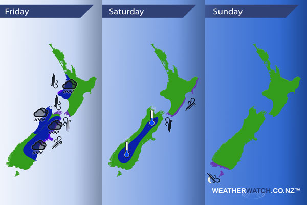
InfoGraphic: The main Weather Highlights across NZ for next 3 days
13/10/2016 6:00pm

> From the WeatherWatch archives
A low pressure system sits around central New Zealand today while a front crosses the North Island and a southerly airflow moves north for the east of the South Island. A southwesterly airflow lies over the country on Saturday then tending more northwest on Sunday.
Friday
Blue – Some rain for the east of the South Island with the chance of few heavy falls, easing about Otago early this morning and reaching Canterbury in the afternoon. While rain may be heavy for a time it moves on fairly promptly so issues should remain at a minimum.
Some rain moves onto Taranaki and just north of there around late morning which could bring a few heavy falls then easing, this rain / front moves along fairly quickly.
Some early morning heavy rain for North Westland / Buller then easing.
Purple – Southwesterly winds about the coastal fringes of the east coast of the South Island will be strong from the southwest for at time, a low risk of gales. Overnight strong to gale southerly winds move into the lower North Island.
Northerly winds through central New Zealand are brisk to strong this morning then easing early afternoon.
Saturday
Blue – It may be a frosty start about the interior of the South Island.
Purple – Strong south to southwesterly winds ease from afternoon about Wellington then from the east coast of the North Island overnight.
Sunday
Purple – Northwesterly winds becoming strong with a low risk of gales about the lower South Island overnight.

– Please note, the idea behind this update is to focus on the main weather highlights, which is why not all regions are mentioned.
For specific 10 day information for your city, town, rural community or island please see the 1500 forecasts on our homepage!
– Aaron Wilkinson, WeatherWatch.co.nz
Comments
Before you add a new comment, take note this story was published on 13 Oct 2016.


Add new comment