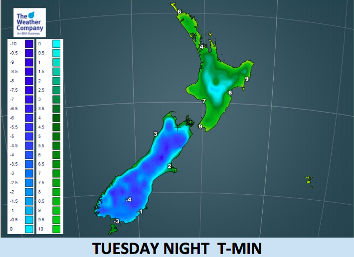
Frosts tonight, heavy in the South Island and creeping as far north as Auckland (+3 Maps)
29/05/2018 2:54am

> From the WeatherWatch archives
When there’s ice on cars north of Auckland you know it must be freezing cold further south and that was the case this morning and will be the case again overnight as the coldest part of this southerly event now grips New Zealand.
The frosty weather may even brush inland parts of Northland tomorrow morning and people with frost sensitive plants may want to put sheets or protection over them this evening around sunset. Frosts are only borderline, but are possible in sheltered areas away from the coast.
However further south, where frost sensitive plants are not usually a issue, the overnight lows will be well down tonight with -5C possible through parts of Otago and -3C around a bit part of Southland.
Today Queenstown’s high will be just two degrees, the same as Hamilton’s overnight low.
The cold snap peaks today and overnight for most places. By Wednesday and Thursday nights there may be an extra degree or two for many areas, although eastern parts of the North Island may experience their coldest weather as the southerly winds, showers and clouds finally move away from that side of the country.
Any frosts in northern parts of New Zealand won’t be very heavy with lows hovering near or just above freezing for the most part, but the frosts in Southland and inland Otago and inland Canterbury will be heaviest. It will be frosty in Nelson and Marlborough, inland West Coast and pockets of the North Island (mainly away from the coastlines).


– WeatherWatch.co.nz
Comments
Before you add a new comment, take note this story was published on 29 May 2018.


Add new comment
LM on 29/05/2018 12:14am
Queenstown is currently 4 degrees. A bit warmer than the 2 degrees suggested in your story!
Reply
WW Forecast Team on 29/05/2018 4:07am
2 degrees isn’t much difference, there were stations recording lower in the area too! Chilly stuff! Thanks for the regular critiques.
– WW
Reply