Drought Watch: After Uesi comes the chance of isolated showers for drought zones next week
15/02/2020 9:19am

> From the WeatherWatch archives
Ex-cyclone Uesi may be missing the North Island – but the leftovers may produce some welcome downpours next week in NZ’s driest regions.
Showers, by definition, are off and on and hit and miss – so not everyone will be lucky enough to get some rain. But in New Zealand some of our droughts get fixed this way, by repetitive afternoon downpours rather than a low bringing rain.
Uesi the storm will miss the North Island entirely, other than high cloud on Friday and Saturday, but the leftovers and the shift to more humid nor’easters after Uesi has tracked south means next week has the best opportunities for downpours basically so far this year in some of the North Island’s drought zones.
Downpours will be inland for the most part, but may drift to some coastal areas later. They will mostly form through Waikato and Northland and towards Gisborne and Hawke’s Bay with next Tuesday, Wednesday and Thursday perhaps the best opportunities.
This will not reverse the technical drought, but will give some localised relief here and there. As depressing as it is to write, the majority will still be drier than normal – but we do have some chances of downpours.
It’s possible these isolated afternoon downpours will also produce a few inland thunderstorms.
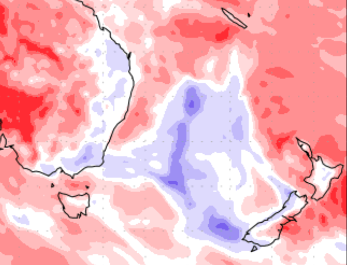
The map below shows the highest risk area – it doesn’t lock in rain for everyone in the shading but that’s where downpours are most likely to A) form and B) drift around in.

RAIN FORECAST COMPARED TO NORMAL: Red = drier than average. White = Normal rainfall for this time of year. Blue = Wetter than usual. This map shows the blue in the Tasman Sea and West Coast from Ex-cyclone Uesi, but it also shows white colouring over the North Island (which has been red for most of this year). This indicates shower / afternoon downpour activity. Data courtesy: US Govt.
– WeatherWatch.co.nz
Comments
Before you add a new comment, take note this story was published on 15 Feb 2020.


Add new comment
Guest on 15/02/2020 2:35am
There looks there might be a couple of tropical disturbances up around Fiji and a bit north. Are these in any way likely to bring some wet weather down towards northern NZ over the next two weeks?
Reply
josh on 13/02/2020 8:20pm
lets hope some drift into auckland . but thats great news
Reply