Details for the next few days as a deep low moves in – and it’s not all serious (+Maps)
17/08/2017 6:18am

> From the WeatherWatch archives
Severe gales in Wellington today, big downpours for some in the past 24 hours, temperatures above 20 degrees too – but Friday looks much quieter. The weekend sees the low move in towards the North Island.
FRIDAY WET WEATHER:
The main weather feature on Friday will be heavy rain on the West Coast – this hopefully will spillover into the hydro-lakes a bit too.
There may be a few isolated showers here or there across New Zealand but most other regions will be dry to mainly dry.
Rain on the West Coast is worthy of monitoring – with so much heavy rain lately streams may rise quickly.
FRIDAY WIND:
Gales continue overnight in more remote, inland and mountainous areas of the South Island and across Friday these winds will ease even further, fading out completely for some.
The North Island has a mainly calm day with variable winds in some regions.
FRIDAY TEMPERATURES – A few highlights
- Southland may climb into the mid teens.
- Canterbury may reach late teens in some places.
- Hawke’s Bay may reach 20.
- Queenstown’s overnight low will be +1
- It should be mild in most places (for this time of year)
WHAT ELSE MAY HAPPEN ON FRIDAY?
While Friday may be fairly quiet in many regions we do actually have a very deep low pressure system moving in and therefore the weather can be unstable. The warmer air around the North Island mixed with a calm day could see some daytime cloud build ups and this may produce a few showers or downpours. There’s a fairly low risk of an isolated thunderstorm but most places should be dry and quite calm as we go through Friday.
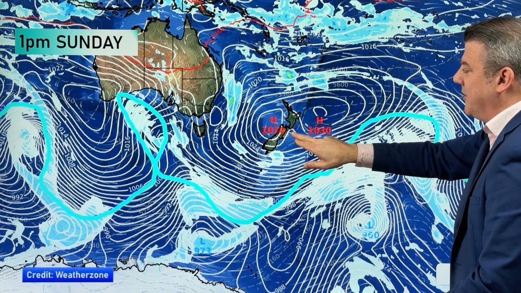
THE WEEKEND – THE DEEP LOW COMES INTO THE NORTH ISLAND:
The good news is that the worst of the winds from this low will be mostly in the Tasman Sea between the centre of NZ’s low and the big high building over eastern Australia. As the low moves into the North Island it should be weakening and so those worst winds out at sea will also weaken as they move towards land. But, we may see some blustery conditions pop up here and there, so worthy of monitoring any potential weather warnings etc. There will also a lot of calm/average weather.
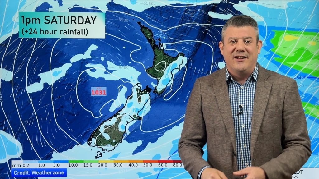
Rain-wise the weekend sees heavy downpours in the northern and western side of both islands on Saturday – good sleep in weather. By Sunday there may be a narrow band of quite heavy rain feeding into North Canterbury/Cook Strait/Wairarapa area, with showers elsewhere, mainly in the north.
CANTERBURY RAIN/FLOODING RISK THIS WEEKEND:
At low elevations rainfall totals currently don’t look too bad – but this narrow area of forecast rain is what we call “one to watch”. A bit like a plane needs to line up to a runway we need to line up the data to be as accurate as possible and – like a plane approaching a runway – the closer you get the easier it is to see, so this will become clearer to us if concerning or not over the next 24 to 48 hours.
The latest weather data we trust shows entire weekend rainfall totals in some coastal Canterbury areas as low as 7 to 10mm, but others do have higher amounts of maybe 25 to 50mm. Most likely totals above that will be quite isolated – but we’ll need to get closer to the weekend.
 ABOVE: Noon Friday
BELOW: Noon Saturday
*If it wasn’t for two recent flood events it’s unlikely we’d be focused on this type of rainfall for Canterbury – just to balance our coverage.
**Check out our latest Infographic for Friday – and of course on Friday we’ll have our next detailed weather update with Philip Duncan, to track Friday evening, the weekend and how next week is shaping up.
***Speaking of next week – if you need some good news – you may want to have a look at our news story from earlier today about the forecast next week. We break it down, wind-wise, rain-wise and temperature-wise..oh and an pollen/allergies update – click/tap here for this info.
– WeatherWatch.co.nz
Comments
Before you add a new comment, take note this story was published on 17 Aug 2017.


Add new comment