> From the WeatherWatch archives
A low located to the east of North Island has stayed almost in the same position for a few days and is today deepening and drifting a little closer to eastern regions.
This will particularly affect the east coast of the North Island with 80km/h winds, heavy rain for some with a little chance of lightning. Gusts above 80km/h are possible. However some regions may only have patchy showers and drizzle.
The offshore low is also creating bigger swells at some of our favourite beaches along with dangerous rips. Parents with young children should especially be aware of these more dangerous coastal conditions from East Cape to Wairarapa (along the North Island’s east coast) with more rips and strong rips for the next couple of days.

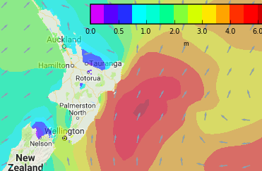
Swell map for later this afternoon (Weathermap.co.nz). Use our maps tab to access more swell maps and zoom in closer to where you are.

 Wind map shows the worst of the winds out at sea but by this evening gales (in pink wind arrows) will brush some exposed eastern areas.
– WeatherWatch.co.nz (an IBM Business Partner)
Comments
Before you add a new comment, take note this story was published on 27 Dec 2017.


Add new comment
B Spicer on 27/12/2017 10:38pm
Hi
Is it just the south east side of the north island eg: Coromandel Peninsula South or further north too?
Thanks
Brett
Reply
WW Forecast Team on 27/12/2017 11:26pm
HI Brett, yes it’s mostly East Cape southwards in the North Island. The Hawke’s Bay/Gisborne Ranges and East Cape areas are all actually helping to protect Coromandel and BOP and Northland from more serious conditions. But swells may still be over 1 metre with waves potentially even around 2 metres in places with a fresh wind.
Cheers
WW
Reply
Paul Jackson on 27/12/2017 10:02pm
My knowledge of marine weather was garnered from books and many ocean crossings. This system warrants mariners attention.
Paul Jackson.
Reply