Your web browser (Internet Explorer) is out of date. Some things will not look right and things might not work properly. Please download an up-to-date and free browser from here.

ClimateWatch: MAY’s outlook as El Niño ends, NEUTRAL pattern arrives (+Video & 13 Maps)

El Niño may be technically gone but the weather pattern it created is still with our part of the world. By that we mean more high pressure south of Australia and drifting towards NZ, bringing long dry stretches and plenty of west to south west winds.

As mainstream news outlets now obsess over La Niña, we’re focused on the reality of what is happening now – and what is coming in for winter.

May looks similar to April with some powerful high pressure zones but also a few cold fronts in the mix. The sub-tropics are fairly quiet but the second week of May might see a sub-tropical disturbance that brings some wet weather and windier easterlies to northern NZ (but it’s not locked in due to the powerful high pressure zones coming out of Australia and into southern NZ).

Generally speaking the Neutral pattern we’re in now means there is more variability – but don’t expect any dramatic changes just yet. International modelling suggests the neutral phase will last for the rest of winter and possibly well into spring, so talking beyond that is fairly unhelpful at this stage. Various models still disagree on what happens later this year – so for now we’re best to focus on the upcoming winter and how the fading El Niño weather pattern is going to look.

May is likely to lean drier than average, but in saying that there’s still some follow up wet weather for some regions. Despite some cooler days and nights, we still expect May to lean a little warmer than average.

According to the Bureau of Meteorology (BoM) – El Niño is now over.
BoM’s model of all models, shows we’re very much in Neutral now…and will likely be here well into Spring.
What the various Government Agencies around the world say.
(NIWA modelling from NZ is excluded from this graphic as they don’t provide open data, unlike the rest of the modern world. NIWA is sadly fiercely commercial these days – or they don’t have faith in their modelling being openly displayed due to it’s very poor accuracy).

AIR PRESSURE IN MAY…

WEEK 1 – Kicks off how April ended – with massive high pressure south of Australia and some low pressure east of NZ and south of NZ. The set-up encourages west to south-west winds in many parts of NZ for the first few days of May, then lighter winds as high pressure increases.
WEEK 2 — High pressure spreads out eastwards across the South Island and parts of the North Island but another sub-tropical ‘disturbance’ (a low trying to form) will likely be in the mix. Depending on how the high pressure systems track across NZ this may bring in a burst of rain and wind for the North Island in the second week of May, but it’s not 100% locked in – the high pressure belt is the controlling/deciding factor.
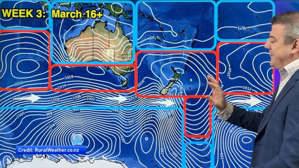
WEEK 3 – High pressure is mostly in control with some weak areas of low pressure at our latitude. The high pressure belt here means there may be a lack of colder southerlies in the mix too. The Southern Ocean is quite orderly and westerly driven… it looks like early Autumn rather than mid to late Autumn in our view. These maps are powered by Weatherzone, created by WeatherWatch.

UPCOMING RAINFALL…

How much wetter or drier is the first week of May compared to usual? For most places it’s leaning drier than usual…although a small area of wet weather near the North Island is trying to move in. Map courtesy: GrADS/COLA
The Big Picture: High pressure dominates the southern part of Australia, in particular VIC and TAS. These highs are also impacting NZ with drier sou-west winds. Some sub-tropical wet weather is trying to slide into NZ from the north and east – but the highs from Australia will be pushing back against that the entire time. Map courtesy Weatherzone, Graphic by WeatherWatch.
Some wet weather to the north and east of NZ will try to brush the North Island and a few westerly showers build up in the west… otherwise not a huge amount of rain around, but hit and miss relief. Map courtesy: Weatherzone

MARINE…

Map Courtesy: The Moana Project
El El Niño may be technically gone but the weather pattern it created is still with our part of the world. This is evident by looking at the soil moisture maps, which show eastern and north-eastern parts of both main islands leaning drier than average still. Map created by the National Institute of Water & Atmospheric Research, a 100% Government Agency / Crown Institute.

View more soil moisture maps at the bottom of the www.RuralWeather.co.nz homepage.

  • ClimateWatch is a premium product made by WeatherWatch.co.nz for RuralWeather.co.nz and is provided FREE of charge.
  • WeatherWatch.co.nz is proud to be a small Kiwi business
  • Please Contact Us if you need unique commercial weather, climate and data services tailored to you. We sell data. We build unique solutions.
  • WeatherWatch.co.nz / New App / RuralWeather.co.nz

Comments

Related Articles