ClimateWatch: DECEMBER – La Niña forms but Southern Ocean is stormier
30/11/2025 11:38pm
La Niña has officially developed, but it’s worth noting the conditions have been around since September with an official announcement needing to lock in these conditions at a particular threshold – which happened last week.
Australia’s Bureau of Meteorology has been consistent for months about it likely forming in late spring/early summer and that it looks fairly weak and short lived. While many news outlets report an official La Niña declaration as if a switch has been flicked the conditions have been in our weather maps for months, so we don’t see any sudden change to our weather pattern around New Zealand and Australia. But the South Pacific islands may get more rain and humidity due to decreased air pressure.
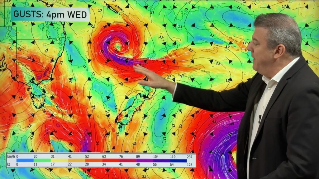
At the same time that La Niña has formed, a vigorous stormy pattern remains over the Southern Ocean area, frequently bringing cold blasts into the south-east quarter of Australia over November, but only brushing the southern South Island of NZ at times.
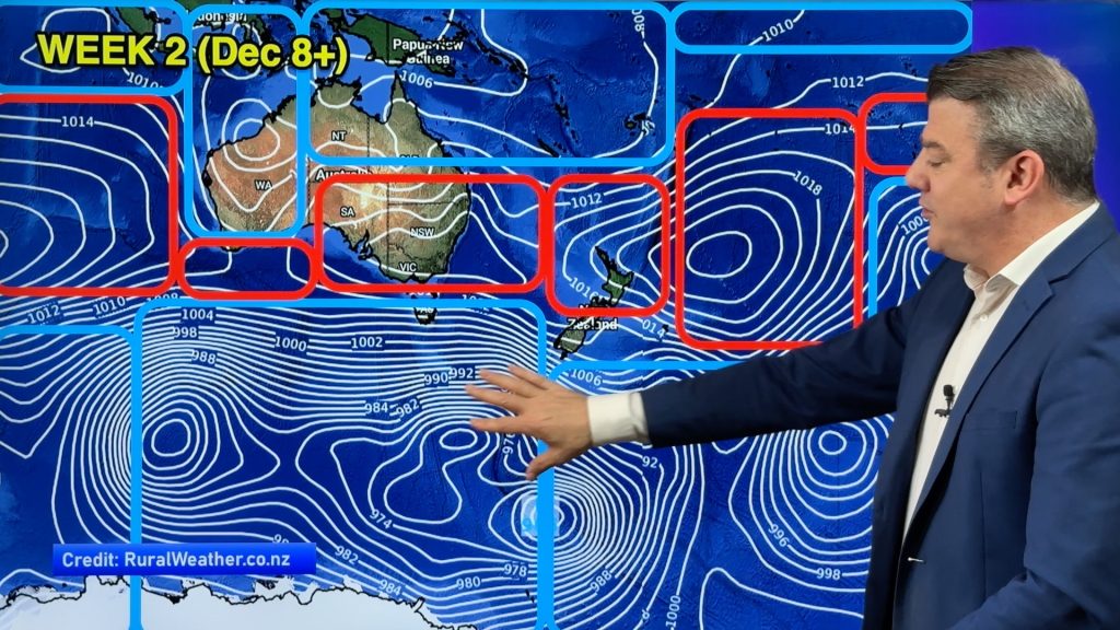
High pressure separates what is happening in the tropics with La Niña and what is going on south of Australia and NZ over the next few weeks.
Put simply, for New Zealand it looks like November’s weather pattern carries on – so for most regions that will feel like a spring pattern (windy at times, changeable) but with many experiencing summer like temperatures.
In Australia it means more high pressure expanding and, for the start of December, an actual reduction in wet weather. But things may change mid to late this month in the tropical side of the central and western Pacific and Australia’s north.
For any La Niña weather conditions to really affect New Zealand we need high pressure to our east, where it pulls down that humidity, not to our north where it can block tropical weather from reaching us. At the moment high pressure is definitely fuelling the temperature swings in both NZ and Australia.
We give you the general Big Picture view, plus 16 day December rainfall, as we go into the start of Summer 2025/26.
Comments
Latest Video

Unsettled Thu/Fri, high pressure returns this weekend & next week
Wind and some wet weather is moving into both ends of NZ today and tomorrow bringing broken up rain bands…
Related Articles
Unsettled Thu/Fri, high pressure returns this weekend & next week
Wind and some wet weather is moving into both ends of NZ today and tomorrow bringing broken up rain bands…
Subtropical low, windy for some, then high pressure slowly returns
It’s cloudy and windy for parts of New Zealand today with the North Island especially gloomy under cloud associated with…

Temperatures to lift, before dropping again this weekend
Subtropical and north-west winds will help boost temperatures around NZ both by day and night followed a colder couple of…


Add new comment
Greg on 1/12/2025 6:24am
It’s been SNOWING all day on Australia’s ski fields – Perisher & Thredbo in NSW and Buller & Hotham in Victoria – 15cm at last check (6pm) and freezing: welcome to ‘summer’.
NZ’s next on the list with snow to 1,500m for the Southern Alps both Tuesday & Wednesday: oh for the good old days when summers were hot… RIP.
Reply
Zelda on 1/12/2025 2:49am
An excellent forecast and story. I do like the tightly packed isobars. I am enjoying the lack of humidity!
Reply