ClimateWatch: August’s Outlook (+15 Maps & extended Video)
2/08/2021 4:02am

> From the WeatherWatch archives
August is looking to lean warmer than average with rain events off and on from the west – but also some large high pressure coming out of Australia. Leaning warmer than average doesn’t mean it feels warm, nor does it mean we won’t have wintry changes – but generally speaking the nation looks to be a little milder.
Some large high pressure systems remain over Australia and northern areas while large lows and storms (normal for August) remain over the Southern Ocean.
SOIL:
July was warmer than average and that’s helping contribute to some fairly mild soil conditions around the country.


AUGUST’S SET UP – AIR PRESSURE
August is looking to start off on a colder note and maybe quite unsettled at times, but as we head into mid August a large high from Australia is likely to move through encouraging westerlies and limiting stormier weather in the NZ area.
August is a highly unstable month weather-wise and while we do our best to cover the general weather patterns in the weeks ahead there can aways be a surprise storm or snowy blast.
As usual, we’ve marked where the highs and lows will be at the start of the next few weeks coming up. For the most part the weather systems are moving from west to east.


RAINFALL

Red = drier than normal, White = normal rainfall for this time of year. Blue = wetter than usual.
This set up shows the South Island’s West Coast looking wettest – in other words, normal weather for August. Biggest downside – still very dry in Hawke’s Bay.


Suggesting while the first week or so of August may be wet on the West Coast, the entire month may lean drier than usual – suggesting the forecast highs may well come in.

AUGUST – SEPTEMBER – OCTOBER
Longer term and rainfall looks to lean a little wetter than usual (not a lot) with some some areas normal or even drier than usual (such as the eastern side of the North Island and around Fiordland, Otago and Southland.
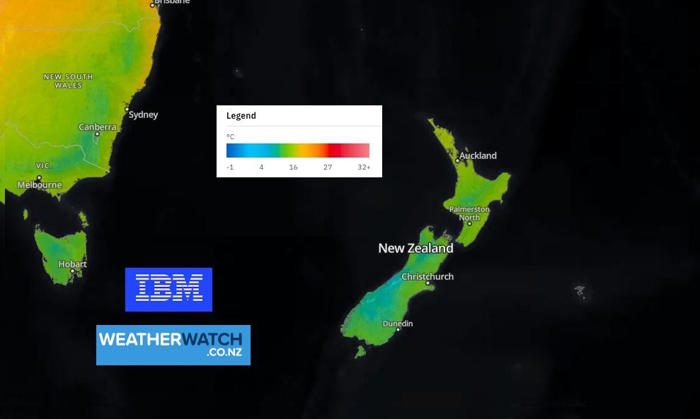
TEMPERATURES
July was warmer than average generally speaking across New Zealand. It shows that even though it’s still cold, it’s not as cold as what has been recorded historically at this time of the year. August is looking similar to July, leaning a little warmer by half a degree to a degree – and that may be due to an uptick in westerlies.

AUGUST
NZ leans warmer by 0.5 to 1C above normal

AUGUST – SEPTEMBER – OCTOBER
Most of NZ leans 0.5 degrees above normal, maybe closer to 1C above normal

Shows marine conditions around NZ are warmer than usual at the moment.

BOTTOM ROW: Shows the Indian Ocean Dipole (Basically their version of La Nina) currently in action but may ease off to Neutral in December.
Both of these rows indicate more wet weather around the tropics north of NZ and around Australia too. This doesn’t directly impact NZ day to day or even week to week – but does suggest more rainmakers will be nearby to the NZ area and some may reach us.
Details above via Australia’s Bureau of Meteorology (BoM). NZ’s Niwa has announced they are now in “La Nina Watch”.
CLIMATEWATCH VIDEO FOR AUGUST:
Comments
Before you add a new comment, take note this story was published on 2 Aug 2021.
Latest Video
Tropical Cyclone VAIANU: Fiji then NZ
Fiji is being affected today by offshore Severe Tropical Cyclone Vaianu and NZ has the chance of a direct hit…
Related Articles
Tropical Cyclone VAIANU: Fiji then NZ
Fiji is being affected today by offshore Severe Tropical Cyclone Vaianu and NZ has the chance of a direct hit…

NZ Easter Weather Update + monitoring the tropics for storm potential
High pressure smothers New Zealand as we head into the long weekend bringing mostly dry weather and light winds, with…

ClimateWatch: APRIL’s outlook as La Niña ends, shift to NEUTRAL
La Niña is officially over and now we’re in a “neutral” period of weather for the month of April, which usually…


Add new comment