
> From the WeatherWatch archives
A deep low near Southland is this weekend pushing heavy downpours, isolated thunderstorms and snow showers across parts of New Zealand with the entire country now engulfed in lower air pressure. Low air pressure makes for more unstable weather.
Most exposed to the heaviest downpours are western regions of both islands and the south western side of the South Island, with southern areas of both islands more exposed into Sunday as winds turn more southerly.
Snow is falling in and around Queenstown and Alpine Passes over the Southern Alps are likely to be impacted by winter driving conditions/heavy snow across the entire weekend.
The colder southerly pushes more into the North Island over Sunday and Monday, then eases as spring-like westerlies return next week along with rising air pressure.
This animation shows the low air pressure (in purple). The yellow coloured airflows were yesterday crossing the North Island with warmer air – today sinking air pressure means colder air from further south is now moving in.
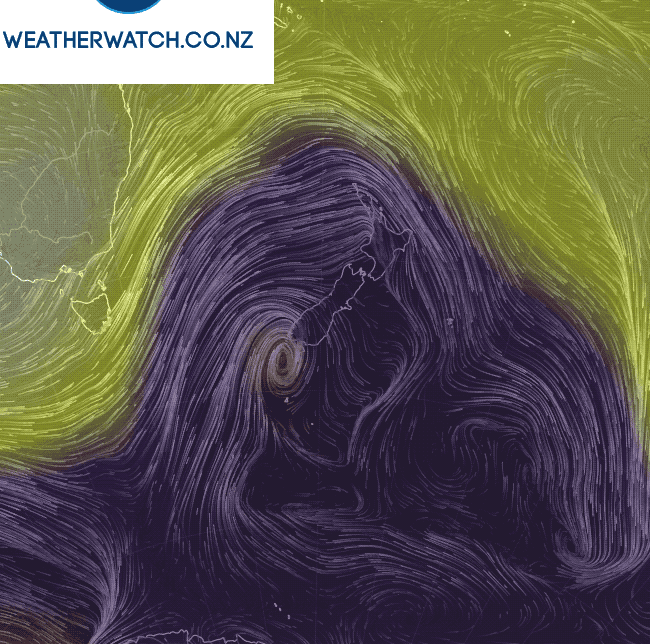 – With data from US Govt & Earth.nullschool.net
– WeatherWatch.co.nz
Comments
Before you add a new comment, take note this story was published on 9 Sep 2017.
Latest Video
Heavy rain, gales, thunderstorms for some – but high pressure is tracking back this week
This week kicks off with a large low bringing instability and changeable forecasts, but as the low drifts over the…
Related Articles
Heavy rain, gales, thunderstorms for some – but high pressure is tracking back this week
This week kicks off with a large low bringing instability and changeable forecasts, but as the low drifts over the…
Large low = chopping & changing forecasts next several days
Expect weather forecasts to shift around a bit over the weekend and across next week in some regions as a…
Large low lingers for weekend & next week
Large lows don’t always equal severe weather – but a low pressue zone larger than New Zealand looks to hang…


Add new comment